L’Allier – Lot B14 à B15
Cournon France


SIZE
420 km
SWIMS
-
ANGLERS
-
STOCK
Good
CARP
40lb +
DIFFICULTY
5/5
LAKE MAP
No
NIGHT FISHING
Yes
L’Allier – Lot B14 à B15
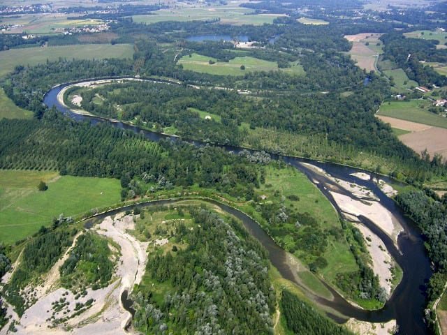
The Allier - Lot B14 to B15 - is a river that flows in the center of France, in the department of Puy-de-Dôme, in the Auvergne-Rhône-Alpes region. It is one of the main tributaries of the Loire. The river and its valley constitute a major axis around which the former province of Auvergne was formed. It is mainly located in the Massif Central, covering a large part of the former Auvergne region and affects the departments, upstream to downstream, of Lozère, Ardèche, Nièvre and Cher. Its course is 420 kilometers. It is one of the last still wild rivers in Europe. It is rich in shallow coastal wetlands, backwaters at certain times of the year, gravel pits, allowing the natural development of exceptional flora and fauna. It has a great diversity of fish (grayling, pike, carp and many others). Very popular with fishermen and nature lovers.
Facilities
- Bait Available
- Tackle Hire
- Expert Guide
- Bait Boats
- Rowing Boats
- Lockbox
- Disabled Access
- -
- -
- -
- -
- -
- -
- -
- Toilets
- Food
- Showers
- Hot Water
- BBQ
- Car Parking
- Dogs Allowed
- -
- -
- -
- -
- -
- -
- -
Specifications
Use:
Type:
Size:
Swims
Max Anglers:
Stock:
Carp Weight:
Difficulty:
Night Fishing:
Fishing
River
420 km
-
-
Good
40lb +
5/5
Yes
Rules
3 rods maximum. Fishing only with vegetable baits. Echosounder authorized on this site. Authorized navigation. Each fisherman must signal his presence by a luminous device. Puy de Dôme fishing federation
-
Description
L’Allier – Lot B14 à B15
The Allier - Lot B14 to B15 - is a river that flows in the center of France, in the department of Puy-de-Dôme, in the Auvergne-Rhône-Alpes region. It is one of the main tributaries of the Loire. The river and its valley constitute a major axis around which the former province of Auvergne was formed. It is mainly located in the Massif Central, covering a large part of the former Auvergne region and affects the departments, upstream to downstream, of Lozère, Ardèche, Nièvre and Cher. Its course is 420 kilometers. It is one of the last still wild rivers in Europe. It is rich in shallow coastal wetlands, backwaters at certain times of the year, gravel pits, allowing the natural development of exceptional flora and fauna. It has a great diversity of fish (grayling, pike, carp and many others). Very popular with fishermen and nature lovers.
-
Facilities
- Bait Available
- Tackle Hire
- Expert Guide
- Bait Boats
- Rowing Boats
- Lockbox
- Disabled Access
- -
- -
- -
- -
- -
- -
- -
- Toilets
- Food
- Showers
- Hot Water
- BBQ
- Car Parking
- Dogs Allowed
- -
- -
- -
- -
- -
- -
- -
-
Specifications
Use:
Type:
Size:
Swims
Max Anglers:
Stock:
Carp Weight:
Difficulty:
Night Fishing:
Fishing
River
420 km
-
-
Good
40lb
5/5
Yes
-
Rules
3 rods maximum. Fishing only with vegetable baits. Echosounder authorized on this site. Authorized navigation. Each fisherman must signal his presence by a luminous device. Puy de Dôme fishing federation
-
Lake Map
Advice for fishing in France can be found HERE.

-
Lake Video
-
Location
Advice for fishing in France can be found HERE.
GPS:
Lat 45.746440887451
Lon 3.217258214951 -
Contact
-
Live Weather