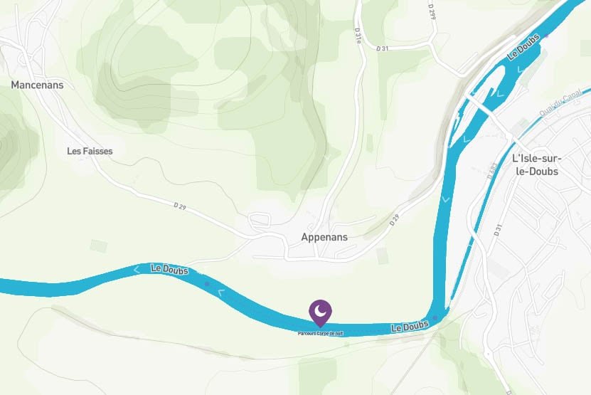
Le Doubs – Parcours Écluse 27 de l’Isle/Doubs au Barrage d’Appenans
Isle-sur-le-Doubs France
SIZE
1600 mtr
SWIMS
-
ANGLERS
-
STOCK
Good
CARP
45lb +
DIFFICULTY
4/5
LAKE MAP
No
NIGHT FISHING
Yes
Le Doubs – Parcours Écluse 27 de l’Isle/Doubs au Barrage d’Appenans
The night carp route from Lock 27 de l'Isle / Doubs (canal confluence) to the Appenans Dam is located on the river Le Doubs, in the Doubs department (25), in the Bourgogne-Franche-Comté region. The Doubs is a French and Swiss river crossing three departments: the Doubs (25) to which it gave its name, the Jura (39) and the Saône-et-Loire (71), as well as the Swiss cantons of Neuchâtel and Jura . It is the main tributary of the Saône and therefore a sub-tributary of the Rhône. Its total length is 453 km, including 430 km on French territory and 85 km on Swiss territory, part of its route serving as the border between the two States. It is the tenth French river by length and the fourth French river after the Marne, the Lot and the Saône, as well as the ninth Swiss river by its length. It has its source in a cavity in the Jura massif located in the French commune of Mouthe at an altitude of 945.5 meters. It offers great fish wealth with the presence of many species of white fish, predators and cyprinids. The fishing pressure is relatively low and the carp are not suspicious. The main difficulty of fishing lies in the wind and the current which is quite strong especially at the beginning of the season. But it is all these random conditions that make the charm of river fishing ... The carp are cut to fight against the current and offer magnificent fights. For the posts, it will be necessary to look first for posts sheltered from the current, a dead arm, an island point, a hole followed by a shoal and congested places (submerged branches, grass beds, water lilies).
Facilities
- Bait Available
- Tackle Hire
- Expert Guide
- Bait Boats
- Rowing Boats
- Lockbox
- Disabled Access
- -
- -
- -
- -
- -
- -
- -
- Toilets
- Food
- Showers
- Hot Water
- BBQ
- Car Parking
- Dogs Allowed
- -
- -
- -
- -
- -
- -
- -
Specifications
Use:
Type:
Size:
Swims
Max Anglers:
Stock:
Carp Weight:
Difficulty:
Night Fishing:
Fishing
River
1600 mtr
-
-
Good
45lb +
4/5
Yes
Rules
Vegetable baits only. Carp is classified as "No Kill", all captured carp must be returned to the water immediately after possible photography. Storage bag prohibited. Camping and fires prohibited outside the developed and regulated areas. See the interactive map of Doubs.
-
Description
Le Doubs – Parcours Écluse 27 de l’Isle/Doubs au Barrage d’Appenans
The night carp route from Lock 27 de l'Isle / Doubs (canal confluence) to the Appenans Dam is located on the river Le Doubs, in the Doubs department (25), in the Bourgogne-Franche-Comté region. The Doubs is a French and Swiss river crossing three departments: the Doubs (25) to which it gave its name, the Jura (39) and the Saône-et-Loire (71), as well as the Swiss cantons of Neuchâtel and Jura . It is the main tributary of the Saône and therefore a sub-tributary of the Rhône. Its total length is 453 km, including 430 km on French territory and 85 km on Swiss territory, part of its route serving as the border between the two States. It is the tenth French river by length and the fourth French river after the Marne, the Lot and the Saône, as well as the ninth Swiss river by its length. It has its source in a cavity in the Jura massif located in the French commune of Mouthe at an altitude of 945.5 meters. It offers great fish wealth with the presence of many species of white fish, predators and cyprinids. The fishing pressure is relatively low and the carp are not suspicious. The main difficulty of fishing lies in the wind and the current which is quite strong especially at the beginning of the season. But it is all these random conditions that make the charm of river fishing ... The carp are cut to fight against the current and offer magnificent fights. For the posts, it will be necessary to look first for posts sheltered from the current, a dead arm, an island point, a hole followed by a shoal and congested places (submerged branches, grass beds, water lilies).
-
Facilities
- Bait Available
- Tackle Hire
- Expert Guide
- Bait Boats
- Rowing Boats
- Lockbox
- Disabled Access
- -
- -
- -
- -
- -
- -
- -
- Toilets
- Food
- Showers
- Hot Water
- BBQ
- Car Parking
- Dogs Allowed
- -
- -
- -
- -
- -
- -
- -
-
Specifications
Use:
Type:
Size:
Swims
Max Anglers:
Stock:
Carp Weight:
Difficulty:
Night Fishing:
Fishing
River
1600 mtr
-
-
Good
45lb
4/5
Yes
-
Rules
Vegetable baits only. Carp is classified as "No Kill", all captured carp must be returned to the water immediately after possible photography. Storage bag prohibited. Camping and fires prohibited outside the developed and regulated areas. See the interactive map of Doubs.
-
Lake Map
Advice for fishing in France can be found HERE.

-
Lake Video
-
Location
Advice for fishing in France can be found HERE.
GPS:
Lat 47.439220428467
Lon 6.575595855713 -
Contact
-
Live Weather


